


West PH Sea label on Google Maps backs PH territorial integrity – Romualdez


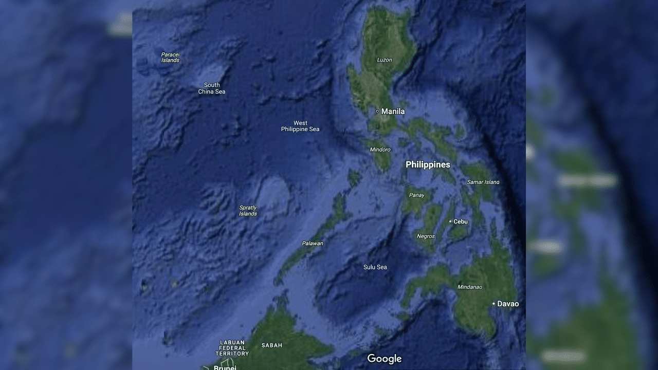
West Philippine on Google Map
MANILA, Philippines — Google Maps’ labeling of the country’s western waters as the West Philippine Sea (WPS) reinforces the government’s assertions on territorial integrity and sovereignty, House of Representatives Speaker Ferdinand Martin Romualdez said on Tuesday.
In a statement, Romualdez said that while the change may seem like a simple update, it reflects global acknowledgment of the country’s efforts to assert that the western waters are part of its exclusive economic zone (EEZ).
“The proper and consistent labeling of the West Philippine Sea on the widely used platform Google Maps is welcome news for every Filipino,” Romualdez said. “This simple yet powerful update reflects the growing global acknowledgment of the Philippines’ sovereign rights over the maritime areas within our Exclusive Economic Zone.”
“This reinforces what we have long asserted: that these waters are part of the Philippines’ territory, and all must respect our sovereign rights,” he added.
READ: West Philippine Sea seen on Google Maps
Romualdez’s statements came after observers noticed that the water west of the country has been labeled as “West Philippine Sea” — instead of the previous designation South China Sea.
Before, WPS labels were only placed as pins entered by netizens or Google Maps users — which led sectors and personalities like Sagip party-list Rep. Rodante Marcoleta to say that the WPS is non-existent.
Marcoleta said this during a House hearing, but he eventually clarified that while it was not wrong to refer to the western waters as WPS, the term was not indicated on international maps.
But Romualdez believes Google’s move is a geopolitical affirmation that adds weight to the Philippines’ claims, coinciding with the Permanent Court of Arbitration (PCA) award in 2016.
According to the PCA, China’s nine-dash line claim—which encompasses part of the WPS—is invalid because it lacks legal and historical basis.
READ: PH wins arbitration case over South China Sea
“Google’s decision to reflect the West Philippine Sea label is more than a map update. It’s a geopolitical affirmation. This platform shapes global consciousness, and this recognition adds significant weight to our cause,” he said.
“For the Filipino people, this is more than just a name on a screen. It is a symbolic and moral victory, a reminder of our decades-long struggle to protect what is rightfully ours,” he added.
The Speaker hopes this change will finally allow other mapping institutions to make the same labels and acknowledge the PCA award and the Philippines’ territorial sovereignty over the WPS.
“Placing the label West Philippine Sea on a leading map acknowledges our rights and sovereignty. This shows that under the eyes of the world, our resolve rooted in law, justice, and world order has meaning and weight,” he said.
“We hope this move will encourage other mapping services, institutions, and governments to follow suit and acknowledge what the law and justice clearly uphold […] The House of Representatives stands firmly behind all efforts that uphold Philippine sovereignty and promote peace and regional stability,” he added.
Tensions between the Philippines and China have been increasing recently after local authorities believe that Chinese aircraft and vessels continue to engage in aggressive and intrusive activities over the WPS.
Just this February, the Philippine Coast Guard spotted four Chinese vessels near Bajo de Masinloc, including the so-called monster ship — Chinese Coast Guard vessel CCG 5901.
Bajo de Masinloc, or Scarborough Shoal, is 124 nautical miles west of Zambales, which means it is inside the 200-nautical-mile EEZ.
Then, on February 18, a Chinese military helicopter came as close as three meters above a Bureau of Fisheries and Aquatic Resources plane conducting a maritime patrol of the Panatag Shoal, another sandbar located inside the EEZ.
READ: Chinese PLA Navy chopper gets as close as 3 meters to BFAR plane
Videos showing that the nine-dash line now includes Palawan and even other parts of Luzon were also posted on Chinese social media platforms.
The National Historical Commission of the Philippines has already clarified that the island of Palawan never belonged to China, noting that the Philippines and its state predecessors have “always exercised sovereignty over our archipelago and over Palawan in particular.”
For comprehensive coverage, in-depth analysis, visit our special page for West Philippine Sea updates. Stay informed with articles, videos, and expert opinions.


